|
||
|
|
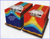
Given the very active hurricane season of 2008 - refreshing our memories of 2005 (Katrina, Rita, and Wilma) and 2004 (Charlie, Frances, Ivan, Jeanne) - there is renewed interest in deploying Atmocean upwelling pumps to cool the upper ocean and reduce hurricane intensity. We have used the GFDL coupled ocean-atmosphere tracking & intensity model used by National Hurricane Center to model the effects on intensity attributable to cooling the upper ocean. From this we have developed the following deployment strategy:
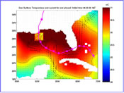
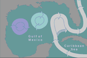
Since the hurricane generates ever-increasing waves, more cold water is pumped as the storm approaches, resulting in overall cooling by about one degree C. - enough to lower peak winds 5% to 20%. Since hurricane damages are proportional to the cube of windspeed, losses could be reduced by 15% (e.g. 100mph reduced to 95 mph) to 49% (100mph reduced to 80mph). Both in 2005 and this year, a portion of the Gulf Stream spun off and formed a large eddy of very warm, deep water in the Gulf of Mexico. If an approaching storm has a well-formed eye, low wind shear in the upper atmosphere, and crosses this warm eddy, rapid intensification is likely. Therefore, a further strategy is to deploy Atmocean pumps weeks ahead of time in the warm eddy to reduce its heat content and mitigate against rapid intensification. We hope to conduct further modelling of this strategy in the near future. |
|


